Milton Pass Debate: To Close or Keep Open?
Before and After Hurricane Milton
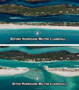
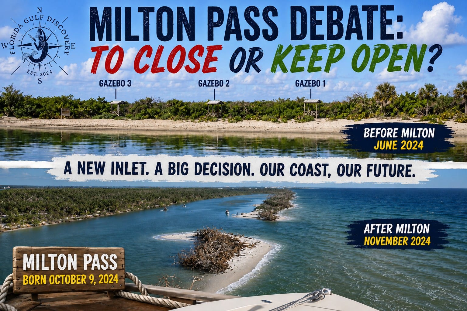
Milton Pass and Ski Alley before and after Hurricane Milton, Florida Gulf Discovery LLC
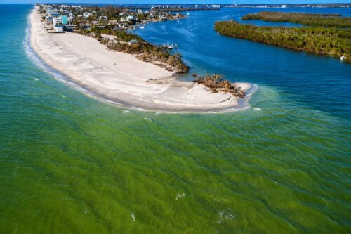
Milton Pass was created by Hurricane Milton on October 9, 2024, when the storm cut a new channel through the barrier island at the southern end of Manasota Key, dividing the land within Stump Pass Beach State Park.
In only a matter of hours, an area that had been beach, dunes, and vegetation became a new connection between the Gulf and the protected waters of Ski Alley and Lemon Bay.
Interestingly, this is not the first time an inlet has existed in this general area. Historical maps show that Stump Pass was located farther north in the late 1800s than it is today, illustrating just how dynamic this barrier-island coastline has always been.
Passes open, migrate, narrow, and close. Sand moves. Islands change shape. Hurricanes can dramatically accelerate processes that otherwise take many years.
Milton Pass is the latest chapter in that continuing story.
The Debate Begins
Following the creation of Milton Pass, questions quickly arose about its future.
At a meeting of the Charlotte County Commissioners, officials discussed recommendations against maintaining two passes along this section of the barrier-island system.
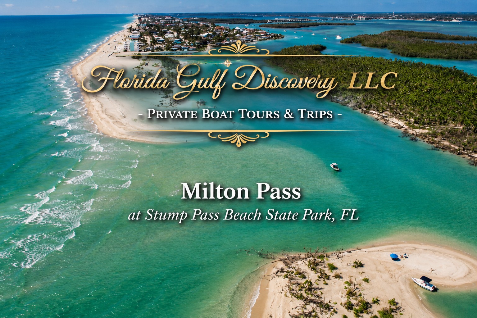
The newly created Milton Pass crosses Stump Pass Beach State Park and provides another connection between the Gulf and the waters behind the barrier island, while the established Stump Pass remains farther south.
The concern is understandable: two nearby passes can influence tidal circulation, sediment transport, erosion, shoaling, and the long-term configuration of the barrier island.
County consultants recommended that Milton Pass should not remain open.
After reviewing the recommendations presented by the county consultants, I respectfully disagree with their position on the proposed closure of Milton Pass.
My concern is not simply whether Milton Pass is convenient for boaters. The more important question is whether enough field-based evidence exists to justify deliberately closing a natural inlet only one year after Hurricane Milton created it.
▶ Click here to watch this video on YouTube: Milton Pass, Ski Alley & Stump Pass Beach State Park – Scenic 4K Drone Tour.
From what I have personally observed while operating in these waters, Milton Pass has become part of the local tidal system. Water now moves through the opening with the tides, creating another pathway for exchange between the Gulf and the protected waters behind the barrier island.
Before making an irreversible decision, I believe we need to understand that new system much better.
That requires comprehensive environmental assessments using on-site measurements, tidal observations, current velocities, sediment-transport studies, water-quality monitoring, bathymetric surveys, and ecological assessments.
It should also include observations from local professionals who regularly operate on these waters and have watched the area change before and after Hurricane Milton.
What Was Here Before Milton Pass?
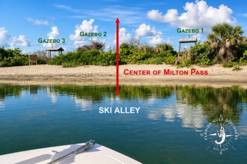
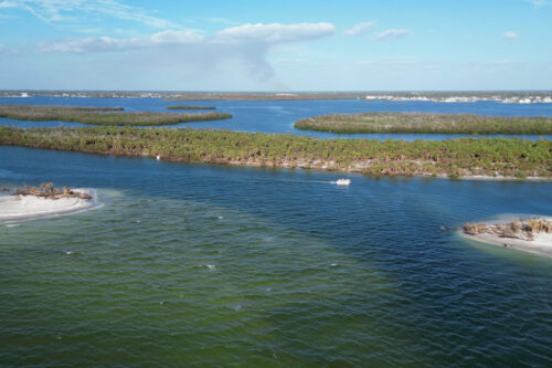
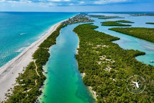
Ski Alley before Hurricane Milton, June 2024, Florida Gulf Discovery LLC
This photograph is particularly important to me because I took it in June 2024—approximately four months before Hurricane Milton.
At that time, there was no Milton Pass.
From Ski Alley, the barrier island was continuous. Beach, vegetation, and dunes separated these protected waters from the Gulf.
The park gazebos visible along the shoreline provide excellent reference points for identifying where the future breach would occur.
Nothing in this photograph suggests that only a few months later boats would be looking directly through this area toward the Gulf.
Then came October 9.
Hurricane Milton changed the landscape in a single day.
That is why I believe we should be very careful about assuming that the shoreline configuration existing before the hurricane represents the only correct configuration for this barrier island.
Nature has been moving this coastline long before any of us arrived here.
Why I Question the Proposed Closure
I have tried to identify the consultants responsible for the recommendation and learn more about the technical basis behind their conclusions. At the time of writing, I have not been able to locate enough publicly available information about the specific consultants, their qualifications, or the complete field data supporting the recommendation to satisfy my questions.
That does not mean the consultants are unqualified.
It means that before supporting such a significant intervention, I would like to see the evidence clearly presented and available for public review.
Closing Milton Pass could be a substantial and expensive coastal-engineering project.
And there is another unavoidable reality:
We live in hurricane country.
Even after spending significant resources restoring the barrier island, another major storm could alter it again.
That possibility should be part of any cost-benefit analysis.
Before committing public resources to closing a naturally created inlet, we should be able to clearly explain what problem we are solving, what scientific evidence demonstrates that closure is necessary, what environmental consequences closure could create, how long the project is expected to last, and what happens if another major storm breaches the island again.
Our community deserves solutions that are scientifically justified, environmentally responsible, and economically sustainable.
Milton Pass Is Part of a Larger Natural System
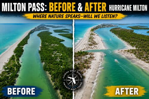
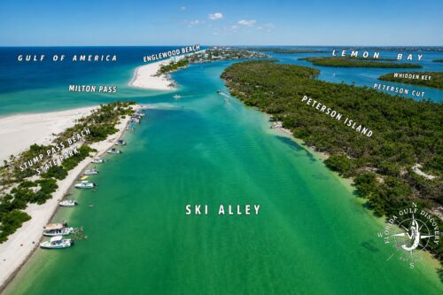
The coastline around Manasota Key, Milton Pass, Stump Pass, and Ski Alley—also known as Peterson Cut—is one interconnected coastal system.
For years, I have explored these waters and Stump Pass Beach State Park, watching tides, winds, currents, cold fronts, tropical systems, and hurricanes continually reshape the landscape.
This coast is never truly stationary.
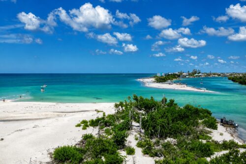
Milton Pass in September 2025, approximately one year after Hurricane Milton, Florida Gulf Discovery LLC
When Hurricane Milton opened the new pass in October 2024, it changed local water movement and sediment patterns almost immediately.
The new inlet began evolving from the moment it was created.
Currents moved sand.
Waves reshaped its Gulf entrance.
Shoals developed.
Shorelines changed.
Depths changed.
And that process continues today.
This is not unusual behavior for a barrier-island system.
What is unusual is that we have been able to watch such a major geographical change happen almost from its beginning.
Protecting Stump Pass Beach State Park
My opposition to immediately closing Milton Pass should not be interpreted as opposition to protecting Stump Pass Beach State Park.
Quite the opposite.
The park protects an extraordinary combination of beaches, mangroves, shallow estuarine waters, seagrass habitat, and wildlife.
Sea turtles nest along these beaches. Shorebirds use the shoreline and shallow flats. Manatees, dolphins, fish, rays, and many other marine species move through the surrounding waters.
This entire area is part of the larger Charlotte Harbor estuarine ecosystem.
Protecting it requires more than deciding whether one opening through the barrier island should be open or closed.
We should be protecting water quality, seagrass, mangroves, wildlife habitat, shorelines, and responsible recreational access throughout the entire system.
That includes responsible boating.
Ski Alley may have a name that suggests speed, but shallow coastal waters and wildlife habitat deserve careful navigation. Excessive speed in sensitive shallow areas can contribute to wake erosion, disturb wildlife, and increase the risk of striking manatees or other marine animals.
Recreation and environmental protection do not have to be enemies.
Good boating means understanding where you are boating.
A Captain’s View From the Water
There is an important difference between studying a waterway on a map and watching it change from a boat.
I have traveled these waters before Hurricane Milton.
I saw Ski Alley when the barrier island was still continuous.
I returned after the hurricane.
I have watched Milton Pass evolve during its first year.
That does not make my observations a substitute for scientific research.
But field observations matter, especially when they are combined with proper scientific measurements.
This is why I believe decisions about Milton Pass should incorporate both rigorous coastal science and direct observations from people familiar with these waterways.
Milton Pass is only about one year old.
Before making a permanent decision about its future, we should understand what it is actually doing.
Could Closing Milton Pass Create Other Problems?
This question deserves careful investigation.
An inlet allows tidal water to move between two bodies of water. Closing that inlet changes that circulation again.
How much?
Where?
With what consequences?
Those questions should be answered with measurements rather than assumptions.
If Milton Pass were closed, would sediment accumulate differently in Ski Alley?
Would water exchange change significantly?
Would another section of the barrier island become more vulnerable?
Would there be measurable effects on Stump Pass?
Would water quality or habitat improve, decline, or remain essentially unchanged?
These are exactly the types of questions that should be answered before, not after, a major intervention.
I am not arguing that Milton Pass must remain open forever.
I am arguing that we should have compelling evidence before deliberately closing it.
There is an important difference.
What About Navigation?
There is another point that boaters need to understand.
Supporting the continued existence of Milton Pass does not mean treating it as a permanent or guaranteed navigation channel.
It is a natural hurricane-created inlet.
Conditions can change rapidly.
Sandbars move. Depths change. Currents vary with the tide. Waves can break near the Gulf entrance. A route that was navigable previously may not be navigable under today’s conditions.
Every captain remains responsible for evaluating current conditions.
Never assume that Milton Pass is safe simply because you—or someone else—passed through it before.
Nature doesn’t maintain channel markers.
One Year After Hurricane Milton
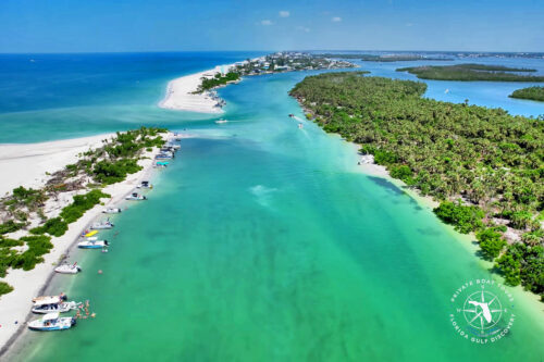
Approximately one year has now passed since Hurricane Milton created this opening.
That makes this an appropriate time to look back.
In June 2024, my photograph shows a continuous barrier island.
Four months later, Hurricane Milton cut through it.
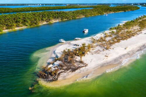
By November 2024, the landscape was dramatically different.
Ski Alley after Hurricane Milton, November 2024, Florida Gulf Discovery LLC
And throughout 2025, Milton Pass continued to evolve.
What happens next?
I don’t know.
And I think admitting that is important.
Milton Pass could continue changing.
It could become narrower.
It could become wider.
Sand could accumulate.
Another storm could dramatically reshape the entire area again.
That uncertainty is exactly why I believe observation and good science should come before irreversible intervention.
Statement from Captain Pavel
As a professional boat captain and long-time observer of our local waterways, I respectfully disagree with the recommendation to close Milton Pass at this time.
My position is not that Milton Pass should necessarily be maintained as a permanent inlet.
My position is that a naturally created pass only one year old should not be deliberately closed without clear, comprehensive, field-based evidence demonstrating that closure provides a greater environmental and public benefit than allowing the coastal system to continue evolving naturally.
Any decision should consider tidal circulation, sediment transport, water quality, marine habitat, navigation, Stump Pass, Stump Pass Beach State Park, recreational use, project cost, and the possibility of future hurricanes reshaping the area again.
Milton Pass was created by nature.
Before we decide that nature made a mistake, we should make very sure that we understand what nature is doing.
Captain Pavel’s Final Thought
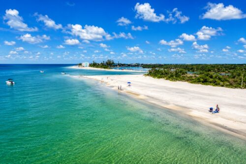
We can debate whether Milton Pass should stay open or be closed.
We can study currents, sediment, tides, navigation, wildlife, and cost.
But there is one thing Hurricane Milton demonstrated very clearly:
We can spend years deciding where we want the coastline to be. Nature can change the decision overnight.
See you on the bay — where the dolphins play at Milton Pass!
— Captain Pavel, Florida Gulf Discovery LLC